Snow Lake Trail: Everything You Need Before Hiking Washington’s Busiest Alpine Lake

More than 21,000 people have logged reviews of this single hike on AllTrails alone, which tells you almost everything about how popular the Snow Lake Trail has become since Alpental’s parking lot turned into one of the busiest trailheads in the entire Alpine Lakes Wilderness. There’s a reason for that popularity, and there’s also a fair bit of confusion around this trail that’s worth clearing up before you show up expecting the wrong thing.
| Detail | Info |
|---|---|
| Trailhead | Alpental Ski Area parking lot |
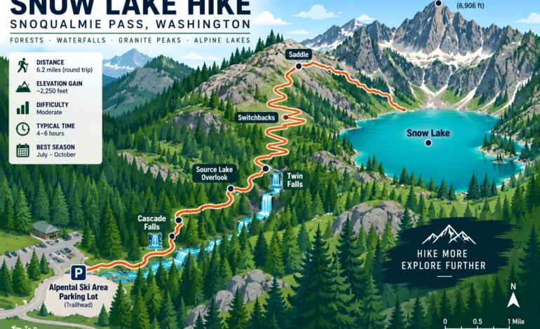
| Distance | 6–7 miles round trip |
| Elevation Gain | 1,300–1,800 feet, depending on source |
| High Point | ~4,400 feet |
| Time Needed | 4–4.5 hours |
| Difficulty | Moderate, with exposed rocky sections |
| Pass Required | Northwest Forest Pass |
First, a Word of Warning About the Name
If you search around online, you’ll run into a second trail with an almost identical name: the Snow Lakes trail inside the Enchantments permit area near Leavenworth. That’s a completely different hike, in a different mountain range, requiring an entirely different permit system. This guide covers the Snow Lake Trail near Snoqualmie Pass, the one that starts from the Alpental Ski Area, not its confusingly-named cousin two hours east.
| Location | Snow Lake Trail (Snoqualmie Pass) | Snow Lakes (Enchantments) |
|---|---|---|
| Alpental, near I-90 | Near Leavenworth | |
| Distance from Seattle | ~50 miles | ~140 miles |
| Permit Needed | Northwest Forest Pass only | Enchantments Wilderness Permit (lottery-based for overnight) |
| Mountain Range Access | Cascade Range, Alpine Lakes Wilderness (west side) | Alpine Lakes Wilderness (east side, Enchantments core) |
| Best For | Day hikers near Seattle | Multi-day backpackers with permits |
Why So Many People Hike This One
Proximity to Seattle explains a lot of it. Exit 52 off I-90 puts you at the Snow Lake Trail trailhead in roughly an hour from the city, which is a shorter drive than almost any other alpine lake destination in the Cascades. Add a genuinely rewarding payoff, a translucent lake tucked beneath Chair Peak, and a moderate difficulty rating that doesn’t require serious backcountry experience, and it’s not surprising the Snow Lake Trail draws crowds that rival far more famous destinations.
Getting There From Seattle
From downtown Seattle, take I-90 East to Exit 52, signed for Snoqualmie Pass West. Turn left, crossing under the freeway, then take the second right and follow the road roughly 1.3 miles to its end at the Alpental parking lot. The whole drive typically runs about 50 miles and just under an hour outside of rush hour traffic, though Friday afternoons and summer weekend mornings can add real delay heading east out of the city.
What the Snow Lake Trail Actually Looks Like
The Snow Lake Trail climbs steadily above the South Fork Snoqualmie River for its first stretch, passing several seasonal waterfalls with Snoqualmie Mountain rising to your right. Around the 1.75 to 2 mile mark, a signed junction offers a short spur trail out to an overlook of Source Lake, the headwaters of the Snoqualmie River’s south fork, worth the small detour if you have time to spare. Past that junction, the trail switches to steeper switchbacks, climbing through more exposed, rocky terrain until it crests a saddle. From there, you’ll actually descend around 400 feet to reach the lake’s shore, a drop you’ll have to regain on the return trip, which surprises a fair number of first-time hikers expecting the whole route to be uphill on the way in.
| Distance Marker | What’s There |
|---|---|
| Start–1.5 miles | Climb through forest, waterfalls, river views |
| 1.75–2 miles | Source Lake Overlook spur trail junction |
| 2–2.8 miles | Steeper switchbacks, exposed rocky sections |
| ~3 miles | Saddle, first full view of the lake below |
| 3–3.3 miles | Descent to the shoreline, remains of an old cabin along a side trail |
If You Want to Keep Going
Snow Lake isn’t actually the end of the trail system for hikers wanting more. Beyond the lake, the route continues toward Gem Lakes and Wildcat Lakes, both considerably quieter than Snow Lake itself once you push past the main crowd. For anyone chasing a bigger day, an ambitious one-way option continues on to Melakwa Lake, involving some off-trail scrambling and a stop at Chair Peak along the way, running roughly 9.3 miles one-way with about 4,400 feet of total elevation gain.
| Destination | One-Way Distance from Snow Lake | Crowd Level |
|---|---|---|
| Gem Lakes | ~2 miles further | Low |
| Wildcat Lakes | ~2.5 miles further | Low |
| Melakwa Lake (via scramble route) | Roughly 9.3 miles total one-way from trailhead | Very Low |
Fishing and Wildlife
Rainbow Trout live in the lake’s waters at the end of the Snow Lake Trail, and while the fishing here has a reputation for being slow, plenty of people bring a rod anyway given how easy the setting makes it to just sit and wait. Pika are common in the rocky sections near the saddle, and the terrain beyond Snow Lake, toward Gem and Wildcat Lakes, sees a noticeable drop in foot traffic and a corresponding increase in genuine backcountry quiet.
A Note on Winter Hiking
Snow Lake stays tempting as a winter destination, and plenty of people do attempt it in the colder months, but the steep terrain in the trail’s first stretch creates real avalanche risk once snow accumulates. This isn’t a trail to treat casually in winter conditions without proper avalanche awareness and equipment, regardless of how manageable it feels during a summer visit.
| Season | Trail Conditions | Recommended For |
|---|---|---|
| Late June–July | Snow often lingering near the saddle | Experienced hikers, microspikes helpful |
| August | Fully clear, warmest | Most visitors, peak crowds |
| September | Clear, cooling, fewer people | Best balance of conditions and crowds |
| October | Cold, early snow possible | Shoulder-season visitors, check conditions first |
| November–May | Snow-covered, avalanche terrain | Only for those with avalanche training and gear |
Packing List for the Snow Lake Trail
| Item | Reason |
|---|---|
| Sturdy footwear | Rocky, exposed sections beyond the Source Lake junction |
| Extra water | No reliable filtered source until you reach the lake |
| Layers | Wind exposure increases noticeably near the saddle |
| Trekking poles | Helpful on the descent to the shore and the return climb back up |
| Early start | Parking fills fast; this is one of the most visited trailheads in the region |
Questions People Ask Before Going
No, and this trips people up constantly. This trail starts at Alpental near Snoqualmie Pass; the Enchantments version is a different trail near Leavenworth requiring its own permit system.
A Northwest Forest Pass is required for parking at the Alpental trailhead. No separate wilderness permit is needed for a day hike to the lake itself.
It’s rated moderate rather than easy, with real elevation gain and rocky, exposed sections past the Source Lake junction. Reasonably fit beginners manage it fine, but it’s not the gentlest option in the area.
Very. This is consistently among the most visited trails in the Alpine Lakes Wilderness, so weekend mornings in summer see full parking lots well before mid-morning and a steady stream of hikers on the trail itself.
Backcountry camping is possible in the area, though the lake’s popularity means finding a quiet spot close to shore during peak season is genuinely difficult. Pushing on toward Gem or Wildcat Lakes offers a quieter overnight option for anyone equipped for it.