Ptarmigan Ridge: The Mount Baker Trail Locals Don’t Want You to Find

Every time I mention Ptarmigan Ridge to someone who’s already hiked Chain Lakes Loop nearby, I get the same reaction: quiet surprise that something this good sits right next door and somehow stays less crowded. This trail runs along an open ridge with Mount Baker on one side and Mount Shuksan on the other, and honestly, few hikes in Washington deliver two glaciated volcanoes in the same frame with this little effort required to get there. After hiking Ptarmigan Ridge more times than I can count across different seasons, this is the detailed breakdown I wish someone had handed me before my first attempt.
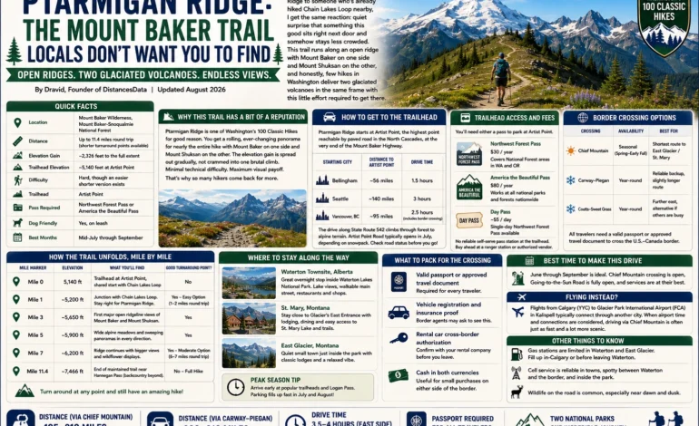
| Detail | Info |
|---|---|
| Location | Mount Baker Wilderness, Mount Baker-Snoqualmie National Forest |
| Distance | Up to 11.4 miles round trip (shorter turnaround points available) |
| Elevation Gain | ~2,326 feet to the full extent |
| Trailhead Elevation | ~5,140 feet at Artist Point |
| Difficulty | Hard, though an easier shorter version exists |
| Trailhead | Artist Point |
| Pass Required | Northwest Forest Pass or America the Beautiful Pass |
| Dog Friendly | Yes, on leash |
| Best Months | Mid-July through September |
Why This Trail Has a Bit of a Reputation
Ptarmigan Ridge is officially recognized as one of Washington’s 100 Classic Hikes, and once you’ve done even the shortened version, it’s easy to see why. Unlike a lot of alpine trails that make you earn a single summit view, Ptarmigan Ridge delivers a rolling, ever-changing panorama for nearly its entire length. You’re rarely more than a few hundred feet from a fresh angle on Mount Baker or Mount Shuksan, and the elevation gain is spread out gradually rather than front-loaded into one brutal climb. That combination of minimal technical difficulty and maximum visual payoff is exactly why Ptarmigan Ridge keeps showing up on best-hikes-in-Washington lists year after year, and why so many hikers who complete Ptarmigan Ridge once end up coming back for a second or third visit.
How to Get to the Trailhead
Ptarmigan Ridge starts at Artist Point, the highest point reachable by paved road in the North Cascades, at the very end of the Mount Baker Highway.
| Starting City | Distance to Artist Point | Drive Time |
|---|---|---|
| Bellingham | ~56 miles | 1.5 hours |
| Seattle | ~140 miles | 3 hours |
| Vancouver, BC | ~95 miles | 2.5 hours (includes border crossing) |
The drive itself, along State Route 542, is scenic enough to be worth doing slowly, climbing steadily through old-growth forest before opening up into the alpine terrain around Heather Meadows and finally Artist Point. Keep in mind that Artist Point Road typically doesn’t open for the season until sometime in July, depending on snowpack, so calling ahead or checking current road status before a spring or early-summer visit saves a wasted drive.
Trailhead Access and Fees
You’ll need either a Northwest Forest Pass, which runs about $30 annually and covers National Forest areas in Washington and Oregon, or an America the Beautiful Pass at $80 a year, which works here and at every national park and forest across the country. A single-day Northwest Forest Pass is also available for around $5 if you’re not planning multiple visits this season. There’s no self-serve payment station reliably stocked at the Ptarmigan Ridge trailhead, so it’s worth purchasing your pass ahead of time from a ranger station or authorized vendor rather than counting on buying one at the lot.
How the Trail Unfolds, Mile by Mile
The ridge along Ptarmigan Ridge is what makes this hike special, and the good news is you don’t need to complete the entire distance to get a genuinely rewarding experience out of it.
| Mile Marker | Elevation | What You’ll Find | Good Turnaround Point? |
|---|---|---|---|
| Mile 0 | 5,140 ft | Trailhead at Artist Point, shared start with Chain Lakes Loop | No |
| Mile 1 | ~5,200 ft | Junction where Ptarmigan Ridge splits from Chain Lakes Loop | No |
| Mile 3 | 5,630 ft | Crest the ridge, trail turns sharply west | Yes, excellent shorter option |
| Mile 3.9 | ~5,900 ft | Panoramic views stretching from Shuksan to Baker | Yes |
| Mile 4.7 | ~6,000 ft | Junction near Coleman Pinnacle, spur toward Camp Kaiser | Optional detour to Goat Lake |
| Mile 4.9 | 6,145 ft | High point of the trail, mountain goats often visible | Yes |
| Mile 5.7 | ~5,900 ft | Rocky spine with views of Sholes Glacier | Yes, for experienced hikers |
| Beyond Mile 5.7 | Varies | Route continues toward the Portals, route-finding required | Experienced climbers only |
If you’re not chasing the full mileage, cresting the ridge around the 3-mile mark already delivers the payoff most people come for: wide-open views of both mountains without the crowds you’d find on the more popular loop next door. The section between mile 3 and mile 5 is genuinely the highlight for most hikers, and turning around anywhere in that stretch still counts as a full, satisfying day.
Distance and Time Options at a Glance
Not everyone wants or needs the full round trip, so here’s how the common variations break down.
| Version | Round Trip Distance | Elevation Gain | Typical Time | Best For |
|---|---|---|---|---|
| Ridge Crest Turnaround | ~6 miles | ~1,000 feet | 3–4 hours | Families, shorter days, first-timers |
| Views Overlook Turnaround | ~7.8 miles | ~1,400 feet | 4–5 hours | Best views-to-effort ratio |
| High Point Turnaround | ~9.8 miles | ~2,000 feet | 5–6.5 hours | Hikers wanting the classic full experience |
| Full Trail to Rocky Spine | 11.4 miles | 2,326 feet | 6–6.5 hours | Experienced hikers wanting maximum mileage |
Wildlife You Might Spot
The exposed, alpine terrain along Ptarmigan Ridge makes wildlife sightings genuinely common on Ptarmigan Ridge compared to more forested trails nearby.
| Animal | Where You’ll Likely See It | Best Time to Spot Them |
|---|---|---|
| Mountain Goats | Near Camp Kaiser and the snowfields below the high point | Midday, resting on snow patches |
| Marmots | Rocky sections along the upper ridge | Morning and late afternoon |
| Pika | Talus slopes throughout the middle portion of the trail | Anytime, listen for their high-pitched call |
| Ptarmigan (the bird) | Occasionally spotted along the ridge, giving the trail its name | Early morning |
| Black Bears | Berry patches lower on the approach, less common near the ridge itself | Dawn and dusk |
Weather and Conditions by Month
Conditions on Ptarmigan Ridge shift dramatically across its short hiking season, and knowing what to expect on Ptarmigan Ridge month to month makes a real difference in how you pack and plan.
| Month | Snow Conditions | Wildflowers | Crowd Level |
|---|---|---|---|
| Late June | Trail often still snowed in near Artist Point | Not yet | Very Low |
| July | Lingering snowfields, especially north-facing sections | Peak bloom | Moderate |
| August | Mostly clear, occasional patches near the high point | Fading, berries ripening | High |
| September | Clear trail, cooler temperatures | Gone, shrubs turning red and orange | Moderate, dropping late in month |
| October | Possible early snow returning | None | Low |
Best Time to Hike It
Mid-July through September is the reliable window, once the snow has mostly cleared from the upper sections. Even within that window, snowfields can linger longer than expected on the north-facing portions of the ridge, so trekking poles and microspikes are worth carrying even in August some years. September brings a real bonus: cooler air, thinner crowds compared to peak summer, and the low alpine shrubs along the ridge turning shades of red and orange, giving the whole hike a completely different character than a July visit. Many experienced Ptarmigan Ridge hikers consider the first two weeks of September to be the single best window of the entire year, balancing clear trail conditions against noticeably smaller crowds.
What to Pack
This trail crosses long, exposed stretches along Ptarmigan Ridge with zero shade, so preparation matters more here than on a typical forested Washington hike.
| Item | Why It Matters |
|---|---|
| Sunscreen and sun hat | Almost the entire trail is exposed, with reflective snow adding to UV exposure |
| Trekking poles | Useful for stability crossing snowfields, especially early morning when they’re icy |
| Microspikes | Worth carrying through midsummer for lingering snow patches |
| Map and compass, or downloaded GPX | Weather changes fast up here and can create whiteout conditions with little warning |
| Extra water | No reliable water sources along most of the route |
| Layers, including a warm jacket | Wind exposure on the ridge makes it feel considerably colder than the valley |
| Bear spray | Standard precaution given black bear activity in berry season |
Photography Tips
If you’re bringing a camera rather than just a phone, early morning light tends to work best on Ptarmigan Ridge, both because the light is softer on Ptarmigan Ridge and because clouds haven’t yet built up around the peaks the way they often do by early afternoon. The stretch between mile 3 and mile 5 offers the widest, most unobstructed views of both mountains simultaneously, making it the natural spot to slow down and actually compose a shot rather than just snapping something quickly while walking. In September, the red and orange alpine shrubs in the foreground add real color contrast against the white glaciers that a summer visit simply won’t give you.
Camping and Backpacking Options
While most people treat Ptarmigan Ridge as a long day hike, backpacking along Ptarmigan Ridge is possible for those who want to slow the pace down. Camp Kaiser, located around mile 4.7, offers informal camping spots with some of the best sunset and sunrise views available anywhere near Mount Baker. There’s no potable water source at the campsites, so anyone planning to stay overnight needs to carry in everything they’ll need or plan on melting snow early in the season. No campfires are permitted anywhere in this area of the Mount Baker Wilderness, so a camp stove is essential if you’re cooking.
How Ptarmigan Ridge Compares to Nearby Trails
If Ptarmigan Ridge is booked into your itinerary but you want options for a different day in the same area, a few nearby trails are worth considering alongside Ptarmigan Ridge itself.
| Trail | Distance | Difficulty | What Makes It Different |
|---|---|---|---|
| Chain Lakes Loop | 7 miles | Moderate | Shares first mile with Ptarmigan Ridge, then loops past 5 alpine lakes |
| Yellow Aster Butte | 7.5 miles | Moderate | Similarly expansive views, different trailhead further north |
| Skyline Divide | 9 miles | Moderate-Hard | Long ridgeline walk with different Mount Baker angle |
| Heliotrope Ridge | 5.6 miles | Moderate | Gets you close to an actual glacier rather than a distant view |
Safety Considerations
The exposure that makes Ptarmigan Ridge so scenic also makes Ptarmigan Ridge genuinely risky in poor weather. Cloud cover can roll in fast at this elevation, and without tree cover to orient yourself, whiteout conditions can turn a straightforward hike disorienting within minutes. Carrying a paper map or a downloaded GPX track as backup to your phone is a reasonable precaution rather than overkill. Snowfields on the north-facing sections stay icy well into the morning during early summer visits, and a slip on one of these slopes near the ridge’s steeper sections can have serious consequences, which is exactly why trekking poles and microspikes show up on every serious guide to this trail.
Frequently Asked Questions
The full distance is rated hard, mainly due to length, elevation gain, and exposed terrain rather than technical difficulty. A shorter version turning around at the ridge crest, around 3 miles each way, is considerably more manageable while still delivering the main views.
No wilderness permit is required, but you do need a valid Northwest Forest Pass or America the Beautiful Pass displayed in your vehicle at the Artist Point trailhead.
Yes, noticeably. Both trails share the same trailhead and first mile, but far fewer hikers continue onto Ptarmigan Ridge once the trail splits, making it a good option if crowds are a concern.
The shortened version of Ptarmigan Ridge to the ridge crest, around 6 miles round trip, is manageable for hikers with moderate fitness and some trail experience. The full 11.4-mile version with its snowfield crossings is better suited to hikers who are comfortable with route-finding and uneven alpine terrain.
No reliable water sources exist along most of Ptarmigan Ridge, so carrying enough water for your entire Ptarmigan Ridge hike is essential, especially given the exposed, sun-heavy terrain.