Blue Lake Trail: North Cascades’ Most Family-Friendly Larch Hike

Ask around Winthrop or Mazama for a hike that works for grandparents, toddlers, and serious photographers all on the same afternoon, and the Blue Lake Trail comes up almost every time. It’s short enough to squeeze into a road trip along Highway 20, easy enough for genuinely mixed-ability groups, and payoff-rich enough that it’s become one of the signature stops for anyone chasing golden larches each fall.
At a Glance
Here’s what to expect from the Blue Lake Trail before you commit to a start time.
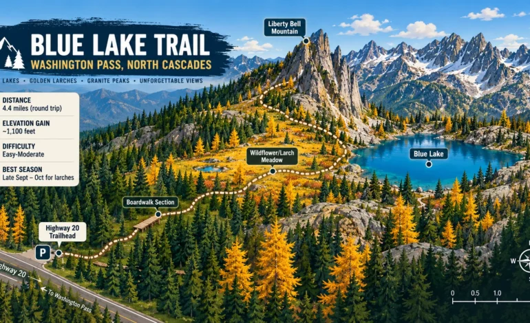
| Distance | 4.4–4.6 miles round trip |
|---|---|
| Elevation Gain | ~1,000–1,100 feet |
| Lake Elevation | 6,254 feet |
| Difficulty | Easy to moderate |
| Time Needed | 2.5–3 hours |
| Trailhead | South side of Highway 20, near Washington Pass |
Getting to the Trailhead
- From Winthrop, drive west on Highway 20 (the North Cascades Highway) for roughly 30 miles to the trailhead, located about a mile west of the Washington Pass Overlook.
- From Mazama, the drive is shorter, around 20 miles along the same route.
- From Seattle, expect roughly 165 miles and 3 to 3.5 hours, most of it along the scenic North Cascades Highway corridor.
The parking lot sits directly off the highway, so there’s no rough access road or extra driving once you leave Highway 20 to reach the Blue Lake Trail, which is part of why this trail sees so much traffic from people simply passing through on a longer road trip.
What the Blue Lake Trail Actually Feels Like
The first quarter mile runs flat, paralleling the highway before the trail crosses a series of short boardwalks and settles into cool, shaded forest. From there, a gradual climb carries you toward Liberty Bell Mountain, a well-known climbing destination, with occasional breaks in the trees offering early glimpses of the surrounding peaks. Around the 0.9 mile mark, the trail opens into a broad meadow, thick with wildflowers in summer and lined with golden larches come fall. Past the meadow, the trail curls around the back side of Liberty Bell, crosses a small logjam near the lake’s outlet, and finally opens up to Blue Lake itself, framed by the Early Winter Spires and Cutthroat Peak.
| Mile Marker | What’s Around You |
|---|---|
| 0–0.25 | Flat section, boardwalks, parallel to the highway |
| 0.25–0.9 | Gradual climb through forest |
| 0.9 | Open meadow, wildflowers or larches depending on season |
| 0.9–2.0 | Views of Liberty Bell, Whistler Mountain, Cutthroat Peak |
| 2.0–2.2 | Logjam crossing, arrival at the lake shore |
Fall Colors and the Rest of the Year
This trail’s reputation rests heavily on its fall display, and it’s the main reason the Blue Lake Trail draws crowds from across the state each autumn. Larches on the surrounding slopes turn a bright golden yellow typically in late September through the first half of October, and because the meadow section sits close to the trail rather than requiring a detour, families and casual hikers get an easy, close-up view most larch hikes don’t offer. Outside of that window, summer brings full wildflower meadows instead, and the lake itself stays a striking, almost unreal blue color throughout the season that gives the trail its name.
| Season | What You’ll See |
|---|---|
| June–early July | Snowmelt, early wildflowers, possible lingering snow near the lake |
| Mid-July–August | Full wildflower bloom, warmest water for a quick dip |
| Late September–mid-October | Golden larches, peak crowds, coolest hiking temperatures |
| Late October–May | Highway 20 typically closed for winter |
Goats, Wildlife, and a Word of Caution
Mountain goats are a fairly regular sighting around the lake and the surrounding slopes, and while they’re generally calm around people, keeping a respectful distance matters, especially if you’re hiking with kids who might not know to stay back. A large boulder on the lake’s west side makes a natural spot to sit and watch for wildlife while eating lunch, and it’s often where the best photos of the lake and the peaks behind it come from.
What to Bring for the Blue Lake Trail
| Item | Reason |
|---|---|
| Water | No reliable source beyond what you carry, especially by late summer |
| Sturdy shoes | Roots, rocks, and a small water crossing near the lake |
| Swimsuit (summer visits) | The lake is genuinely swimmable, if cold, on warm days |
| Camera | Frequent, easy photo opportunities the entire way |
| Layers | Highway 20’s elevation means cooler temperatures than lowland trails |
Nearby Trails Worth Pairing With This One
If you’ve got extra time along Highway 20, a couple of nearby trails complement the Blue Lake Trail well without requiring a completely separate trip.
| Trail | Distance | Difficulty | How It Compares |
|---|---|---|---|
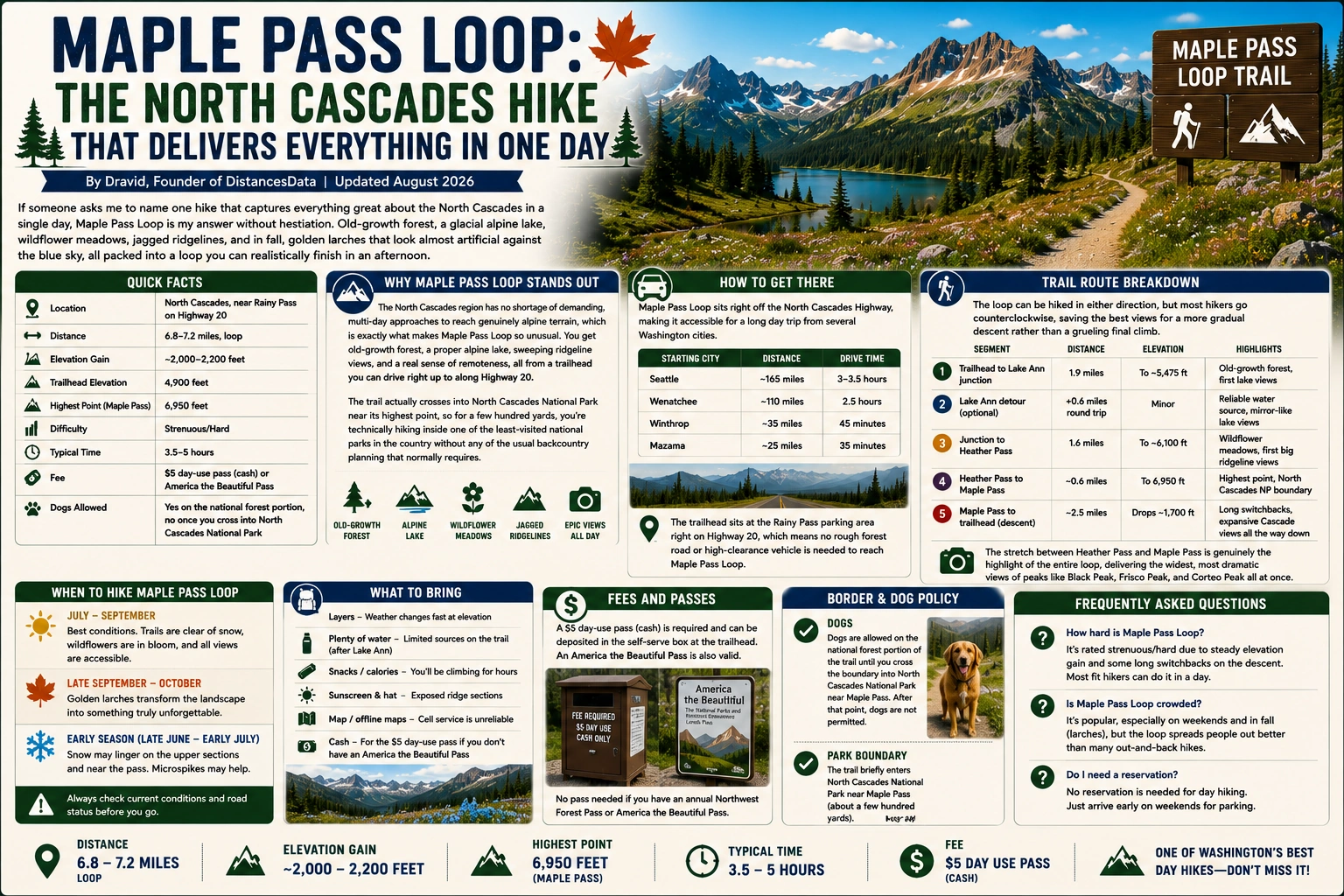
| Maple Pass Loop | 6.8–7.2 miles | Moderate-Hard | Longer, more elevation, similar larch season appeal |
| Cutthroat Pass | 10 miles | Moderate-Hard | Less crowded larch destination further along the highway |
| Washington Pass Overlook | 0.25 miles | Easy | Quick roadside viewpoint, no real hiking required |
Pairing the Blue Lake Trail with a stop at the Washington Pass Overlook makes for an easy half-day outing that covers both an actual hike and one of the highway’s best drive-up views.
Common Questions About This Hike
Most people finish in 2.5 to 3 hours round trip, making it an easy addition to a longer day exploring the North Cascades Highway corridor.
Yes, it’s regularly cited as one of the more family-friendly larch hikes in Washington, thanks to its short distance, manageable elevation gain, and steady stream of interesting scenery along the way.
Typically late September through the first half of October, though exact timing shifts slightly each year depending on weather. This window also brings the heaviest crowds and hardest parking of the entire season.
It can be, especially on weekends during larch season and summer weekends generally, given how easy the access is right off Highway 20. Weekday visits or an early start noticeably improve the experience.
A Few Things Worth Knowing Before You Go
Sign the trail register at the trailhead if one is available; it’s a small step that helps the Forest Service track usage and justify funding for maintenance on trails like this one. If you’re visiting specifically for larches, aim for a weekday if your schedule allows, since this trail’s easy access and reputation make weekend parking genuinely difficult during the peak color window. And if you have extra time after finishing the hike, the short drive up to the Washington Pass Overlook rewards you with one more dramatic view of Liberty Bell and the surrounding spires before you continue along the highway.