Maple Pass Loop: The North Cascades Hike That Delivers Everything in One Day

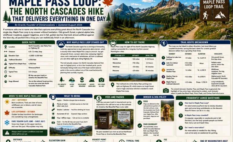
If someone asks me to name one hike that captures everything great about the North Cascades in a single day, Maple Pass Loop is my answer without hesitation. Old-growth forest, a glacial alpine lake, wildflower meadows, jagged ridgelines, and in fall, golden larches that look almost artificial against the blue sky, all packed into a loop you can realistically finish in an afternoon. After hiking Maple Pass Loop in three different seasons, this is everything I wish I’d known before my first attempt.
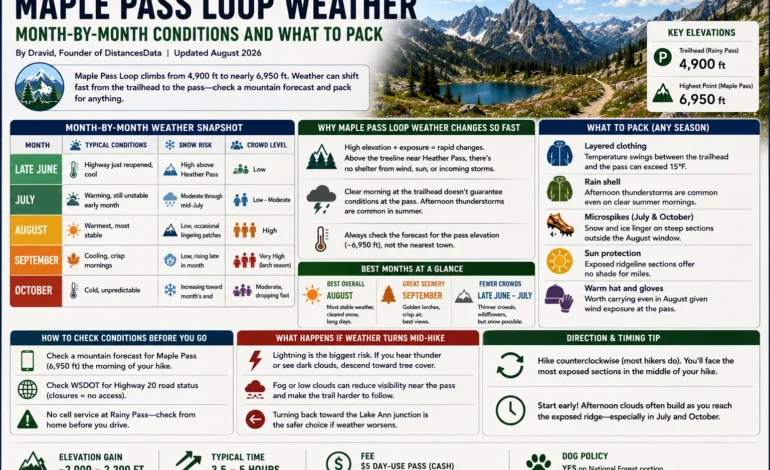
| Detail | Info |
|---|---|
| Location | North Cascades, near Rainy Pass on Highway 20 |
| Distance | 6.8–7.2 miles, loop |
| Elevation Gain | ~2,000–2,200 feet |
| Trailhead Elevation | 4,900 feet |
| Highest Point (Maple Pass) | 6,950 feet |
| Difficulty | Strenuous/Hard |
| Typical Time | 3.5–5 hours |
| Fee | $5 day-use pass (cash) or America the Beautiful Pass |
| Dogs Allowed | Yes on the national forest portion, no once you cross into North Cascades National Park |
Why Maple Pass Loop Stands Out in the North Cascades
The North Cascades region has no shortage of demanding, multi-day approaches to reach genuinely alpine terrain, which is exactly what makes Maple Pass Loop so unusual. You get old-growth forest, a proper alpine lake, sweeping ridgeline views, and a real sense of remoteness, all from a trailhead you can drive right up to along Highway 20. The trail actually crosses into North Cascades National Park near its highest point, so for a few hundred yards, you’re technically hiking inside one of the least-visited national parks in the country without any of the usual backcountry planning that normally requires.
How to Get There
Maple Pass Loop sits right off the North Cascades Highway, making it accessible for a long day trip from several Washington cities.
| Starting City | Distance | Drive Time |
|---|---|---|
| Seattle | ~165 miles | 3–3.5 hours |
| Wenatchee | ~110 miles | 2.5 hours |
| Winthrop | ~35 miles | 45 minutes |
| Mazama | ~25 miles | 35 minutes |
The trailhead sits at the Rainy Pass parking area right on Highway 20, which means no rough forest road or high-clearance vehicle is needed to reach Maple Pass Loop, unlike a lot of comparably scenic hikes in this part of the state.
Trail Route Breakdown
The loop can be hiked in either direction, but most hikers go counterclockwise, saving the best views for a more gradual descent rather than a grueling final climb.
| Segment | Distance | Elevation | Highlights |
|---|---|---|---|
| Trailhead to Lake Ann junction | 1.9 miles | Gradual climb to ~5,475 feet | Old-growth forest, first lake views |
| Lake Ann detour (optional) | +0.6 miles round trip | Minor | Reliable water source, mirror-like lake views |
| Junction to Heather Pass | 1.6 miles | Steady climb to ~6,100 feet | Wildflower meadows, first big ridgeline views |
| Heather Pass to Maple Pass | ~0.6 miles | Climb to 6,950 feet | Highest point, North Cascades National Park boundary |
| Maple Pass to trailhead (descent) | ~2.5 miles | Drops ~1,700 feet | Long switchbacks, expansive Cascade views the whole way down |
The stretch between Heather Pass and Maple Pass is genuinely the highlight of the entire loop, delivering the widest, most dramatic views of peaks like Black Peak, Frisco Peak, and Corteo Peak all at once.
When to Hike Maple Pass Loop
Highway 20 typically closes for winter sometime between late November and the following April or May, depending on snowpack, which effectively defines the hiking season for Maple Pass Loop each year.
| Time Period | Conditions | What to Expect |
|---|---|---|
| Late June–early July | Highway just reopened, snow lingering at the pass | Fewer crowds, possible snow crossings near the top |
| Mid-July–August | Trail fully clear | Peak wildflower bloom, busiest parking and trail traffic |
| Mid-September–early October | Cooling temperatures | Golden larches at peak color, arguably the best window of the year |
| Late October | Cold, possible early snow | Highway can close with little warning |
Late September into the first week or two of October is when most seasoned hikers plan their Maple Pass Loop trip specifically to catch the larches turning gold around Lake Ann and along the upper ridgeline, a sight that draws crowds from across the state.
Parking and Crowds
Maple Pass Loop has become one of the more heavily trafficked trails in the entire North Cascades, and the small trailhead parking lot fills up fast, especially on clear weekends during peak larch season. Arriving before 7 a.m. gives you a real shot at a spot; arriving after 9 a.m. on a September Saturday often means parking well down the shoulder of Highway 20 and walking extra distance just to reach the actual trailhead.
What to Pack
Weather at this elevation shifts quickly, and the exposed sections near Heather Pass and Maple Pass itself offer little shelter if conditions turn.
| Item | Why It Matters |
|---|---|
| Layers, including a warm jacket | Wind exposure at the pass makes it feel far colder than the trailhead |
| Rain shell | Afternoon weather can build quickly at this elevation |
| Sturdy hiking boots | Loose rock and occasional snow patches near the pass |
| Cash for the day-use fee | The $5 fee station only accepts cash |
| Extra water | Lake Ann is the only consistently reliable water source on the loop |
| Downloaded offline map | Cell service at Rainy Pass is virtually nonexistent |
Nearby Alternatives in the North Cascades
If Maple Pass Loop is on your list but you’re looking for something similar nearby, a few other North Cascades trails are worth considering for a multi-day trip in the area.
| Trail | Distance | Difficulty | What Makes It Different |
|---|---|---|---|
| Blue Lake Trail | 4.4 miles | Moderate | Shorter, still delivers strong larch views near Washington Pass |
| Cutthroat Pass | 10 miles | Moderate-Hard | Less crowded larch destination further along Highway 20 |
| Cascade Pass | 7.4 miles | Moderate | Deeper inside North Cascades National Park, dramatic valley views |
Frequently Asked Questions
Most hikers finish in 3.5 to 5 hours, depending on fitness level and how long you linger at the Lake Ann detour and the viewpoints near Heather Pass and Maple Pass.
It’s rated strenuous to hard, mainly due to the steady 2,000-plus feet of elevation gain rather than any technical terrain. Hikers with moderate fitness and some prior trail experience generally manage it fine, but it’s not an easy first hike.
Typically late September through the first week or two of October, though the exact timing shifts slightly year to year based on weather. This window is by far the busiest time to hike Maple Pass Loop, so plan for crowded parking if you’re visiting then.
Dogs are allowed on the national forest portion of the trail, but the loop crosses into North Cascades National Park near its highest point, where dogs are not permitted.